Thermal Drone Survey
Thermal Roof and Building Survey
A radiometric thermal pass over the whole roof and elevations alongside a 100 megapixel visual survey, written up with what the temperature pattern actually shows within 48 hours.
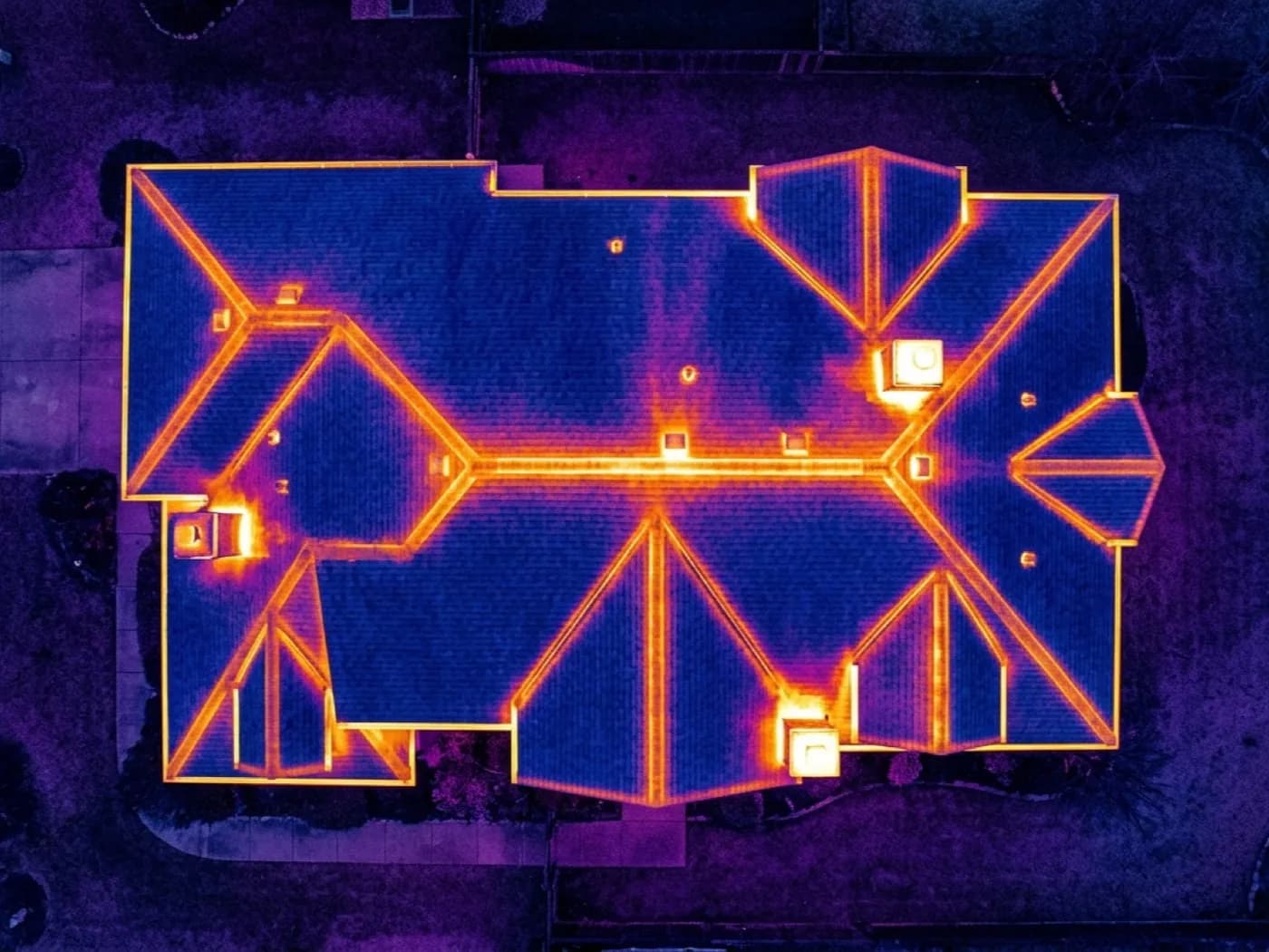
This is the survey most people start with when something is wrong but they cannot say exactly what. A heating bill that has crept up, a house that never quite feels warm however high the thermostat goes, or simply wanting to know what is happening in a roof space nobody has been up into for years.
The aircraft flies the building twice: once with the 100 megapixel visual camera to record what is actually there, ridge, valley, wall, window, extension junction, and once with the radiometric thermal camera to record the surface temperature pattern across the same areas. The two are read together, because a warm patch on its own is a data point and a warm patch matched to a specific roof timber or wall junction is an answer.
What comes back is not a folder of colourful pictures. It is a written account of where the building's surface is warmer or cooler than its surroundings, what that is likely to mean in each case, and where the reading was inconclusive and should not be relied on.
What is included
- Full roof and elevation coverage, visual and thermal, from the same flight
- A note on the conditions the flight was flown in and why they were chosen
- Every significant temperature anomaly located and matched to a building feature
- A plain description of what each finding most likely means
- A written report within 48 hours with the visual and thermal images side by side
- A clear list of anything the thermal camera could not read reliably that day
What the camera actually measures
A radiometric thermal camera measures the temperature of the surface it is pointed at, nothing more. It does not see through a roof covering or a wall finish, it does not detect water directly, and it does not measure how much heat or money is being lost in any given period.
What it is very good at is showing a temperature difference at the surface that would otherwise be invisible: a patch of roof running warmer than the tiles around it because the insulation beneath has failed or was never fitted, or a wall running cooler in one place because damp material is holding more thermal mass than the dry material beside it.
The skill in reading a thermal image is not spotting a colour change, a camera does that automatically. It is knowing which colour changes are a real building defect and which are something else entirely, a shadow, a patch of sun-warmed render, a reflection off a window, and saying which is which plainly in the report rather than flagging everything that looks dramatic on screen.
Why the timing of the flight matters more than almost anything else
A thermal camera needs a genuine temperature difference to show anything useful. Fly a house on a mild, sunny afternoon and the whole building has warmed evenly in the sun, so there is nothing for the camera to read. Fly the same house at dawn after a cold, clear night, with the heating having run overnight, and the pattern of where heat has escaped is written across the roof in plain sight.
That is why a booking conversation for this survey usually includes a question about recent weather and the heating pattern in the building, not just a date in the diary. Dawn or early morning after a cold, clear night is normally best. A cold, still evening after a wet, overcast day works too, because rain complicates a reading in a different way covered on the how thermal imaging works page.
This is also why the survey is not flown to a fixed office-hours slot. If the reading needs six in the morning, that is when the aircraft goes up.
On the day
How a the whole-building scan runs
- Step 1
Timing agreed first
The date is set around the reading, not the diary. A whole-building scan usually wants a period of sustained internal heating against a cold or falling external temperature, so a call about the last few days' weather often comes before a date is confirmed.
- Step 2
Walk round
Ten minutes on the ground first. Which rooms feel cold, when the heating has been running, and anything already noticed, a draught, a damp smell, a patch on a ceiling.
- Step 3
The two flights
Visual coverage first, while there is still enough light to see detail clearly, then the thermal pass once the temperature difference between inside and outside has had time to show at the surface.
- Step 4
The report
Visual and thermal images paired up, findings written in plain words, and a note on confidence for each one. In your inbox within 48 hours.
Behind the work
Kit, cover and qualifications
CAA registered
Operator ID and Flyer ID held, plus the A2 Certificate of Competency. Every flight, including the early morning and after-dark ones this survey often needs, is planned to the rules that apply to the site.
Radiometric thermal camera
A DJI Mavic 2 Enterprise Advanced carrying a 640 by 512 radiometric sensor. Radiometric means every pixel is an actual temperature reading, not just a colour, which is what makes a genuine comparison across a roof or a wall possible.
100 megapixel visual pass
A DJI Mavic 4 Pro with a Hasselblad camera flies alongside the thermal camera on every job, so a warm or cool patch on the thermal image can be matched back to the actual roof feature or wall detail underneath it.
Insured with Coverdrone
Full commercial cover for the operation. Certificates go to managing agents, landlords and insurers as a matter of course, without anyone having to chase for them.
The whole-building scan
Thermal Roof and Building Survey questions
- Do I need to have the heating on for this to work?
- Usually, yes, and running at a normal or slightly higher setting for several hours before the flight, not just switched on that morning. The whole method relies on a real temperature difference between inside and outside showing at the surface, and that takes time to build up.
- What if it has been raining recently?
- Rain changes what a thermal image shows, because wet surfaces read differently to dry ones and can mask or mimic a genuine defect. It is not a reason to cancel outright, but the flight is timed around it, often waiting for the surface to have had a chance to dry, and the report says plainly where recent rain has limited what could be read.
- Can a thermal survey replace an energy assessment or an EPC?
- No. An EPC is a standardised paper assessment based on the building's construction, not a photograph of its actual condition on a given day. A thermal survey is complementary evidence, useful for finding a specific problem, not a substitute for the certificate.
Where
Thermal Roof and Building Survey across the South West
See what it can and cannot see
Book a thermal survey with Thermal Drone Survey
Tell us the address and what you need looking at. Sam Hembury will come back with a fixed price and the next available slot.